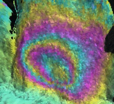
团队主要研究方向包括:
(1)基于合成孔径雷达干涉测量(InSAR)等空间对地观测技术的高山峡谷区滑坡灾害早期识别与监测预警;
(2)基于SAR与多光谱遥感的青藏高原冰川冰湖时空演化规律提取其及灾害链监测与风险评估;
(3)InSAR、多光谱遥感与人工智能结合的滑坡编目、滑坡危险性评估与致灾因子分析;
(4)城市地面沉降InSAR时序监测与建模;
代表性论文:
2022
[19] Dai K., Wen N., Fan X.*, Deng J., Zhang L., Liang R., Liu J., Xu Q. (2021), Seasonal changes of glacier lakes in Tibetan Plateau revealed by multi-polarization SAR data. IEEE Geoscience and Remote Sensing letters.
2021
[18] 卓冠晨,戴可人*,周福军,沈月,陈晨,许强. 川藏铁路典型工点InSAR监测及几何畸变影响精细判识,地球科学,2021
[17] Zhang, L., Dai, K.*, Deng, J., Ge, D., Liang, R., Li, W., Xu, Q. (2021), Identifying potential landslides by Stacking-InSAR in Southwestern China and its performance comparison with SBAS-InSAR, Remote Sensing, 13(18):3662.
[16] 戴可人,张乐乐,宋闯,李振洪*,卓冠晨,许强. 川藏铁路沿线Sentinel-1影像几何畸变与升降轨适宜性定量分析[J].武汉大学学报(信息科学版), 2021. 46(10). (EI,国内T1期刊,国内测绘领域顶刊)
[15] Shi, X., Dai, K.*, Deng J., Zhong, D., Liu G., Pirasteh, P., Zhang, B., Ali, Y., He, Y., Liang, R., (2021), Spatio-temporal evolutionary characteristics of Gongga Mountain glacier group and their response to climate change, Advances in Space Research.
[14] Liang, R., Dai, K.*, Shi, X., Guo, B., Dong, X., Liang, F., Tomás, R., Wen, N., Fan, X. Automated Mapping of Ms 7.0 Jiuzhaigou Earthquake (China) Post-Disaster Landslides Based on High-Resolution UAV Imagery. Remote Sensing. 2021, 13, 1330.
[13] Dai, K., Ran, P., Li, Z.*, Austin, J., Muller, P., Zeng, Q., Zhang, J., Hu, L., (2021), Land Subsidence in Xiongan New Area, China revealed by InSAR observations, Journal of Geodesy and Geoinformation Science.
2016-2020
[12] Zhuo, G., Dai, K.*, Huang, H., Li, S., Shi, X., Feng, Y., Li, T., Dong, X., Deng, J. (2020), Evaluating Potential Ground Subsidence Geo-Hazard of Xiamen Xiang’an New Airport on Reclaimed Land by SAR Interferometry. Sustainability, 12, 6991.
[11] 戴可人, 铁永波, 许强, 冯也, 卓冠晨, 史先琳. 高山峡谷区滑坡灾害隐患InSAR早期识别——以雅砻江中段为例. 雷达学报, 2020, 9(3): 554-568. doi: 10.12000/JR20012 (北大中文核心)
[10] Dai, K., Shi, X.*, Gou, J., Hu, L., Chen, M., Zhao, L., Dong, X., Li, Z. (2020) Diagnosing Subsidence Geohazard at Beijing Capital International Airport, from High-Resolution SAR Interferometry. Sustainability, 12, 2269.
[9] Dai, K., Li, Z.*, Xu, Q., Bürgmann, R., Milledge, D., Tomás, R., Fan, X., Zhao, C., Liu, X., Peng, J., Zhang, Q., Wang, Z., Qu, T., He, C., Li, D., Liu, J. (2020). Entering the era of Earth-Observation based landslide warning system. IEEE Geoscience and Remote Sensing Magazine. 8(1), 136-153.
[8] 戴可人,卓冠晨,许强,李振洪,李为乐,管威.雷达干涉测量对甘肃南峪乡滑坡灾前二维形变追溯[J]. 武汉大学学报(信息科学版), 2019, 44(12):1778-1786+1796. (EI)
[7] Hu, L., Dai, K.*, Xing, C., Li, Z., Tomás, R., Clark, B., … & Lu, Y. (2019). Land subsidence in Beijing and its relationship with geological faults revealed by Sentinel-1 InSAR observations. International Journal of Applied Earth Observation and Geoinformation, 82, 101886.
[6] 葛大庆, 戴可人, 郭兆成, & 李振洪. (2019). 重大地质灾害隐患早期识别中综合遥感应用的思考与建议. 武汉大学学报(信息科学版), 44(7), 949-956. (EI)
[5] Dai, K., Xu, Q.*, Li, Z., Tomás, R., Fan, X., Dong, X., … & Ran, P. (2019). Post-disaster assessment of 2017 catastrophic Xinmo landslide (China) by spaceborne SAR interferometry. Landslides, 16(6), 1189-1199.
[4] Dai, K., Liu, G.*, Li, Z., Ma, D., Wang, X., Zhang, B., … & Li, G. (2018). Monitoring highway stability in permafrost regions with X-band temporary scatterers stacking InSAR. Sensors, 18(6), 1876.
[3] 戴可人.融合新一代卫星SAR数据的地形与形变信息提取模型与方法[J].测绘学报,2018,47(03):422.
[2] Dai, K., Li, Z.*, Tomás, R., Liu, G., Yu, B., Wang, X., … & Stockamp, J. (2016). Monitoring activity at the Daguangbao mega-landslide (China) using Sentinel-1 TOPS time series interferometry. Remote Sensing of Environment, 186, 501-513.
[1] Dai, K., Liu, G.*, Li, Z., Li, T., Yu, B., Wang, X., & Singleton, A. (2015). Extracting vertical displacement rates in Shanghai (China) with multi-platform SAR images. Remote Sensing, 7(8), 9542-9562.
专利:
[1] 顾及局部入射角的高山峡谷区SAR几何畸变识别方法,发明专利
[2] 一种SAR视线向变形与坡度坡向敏感度计算方法,发明专利
